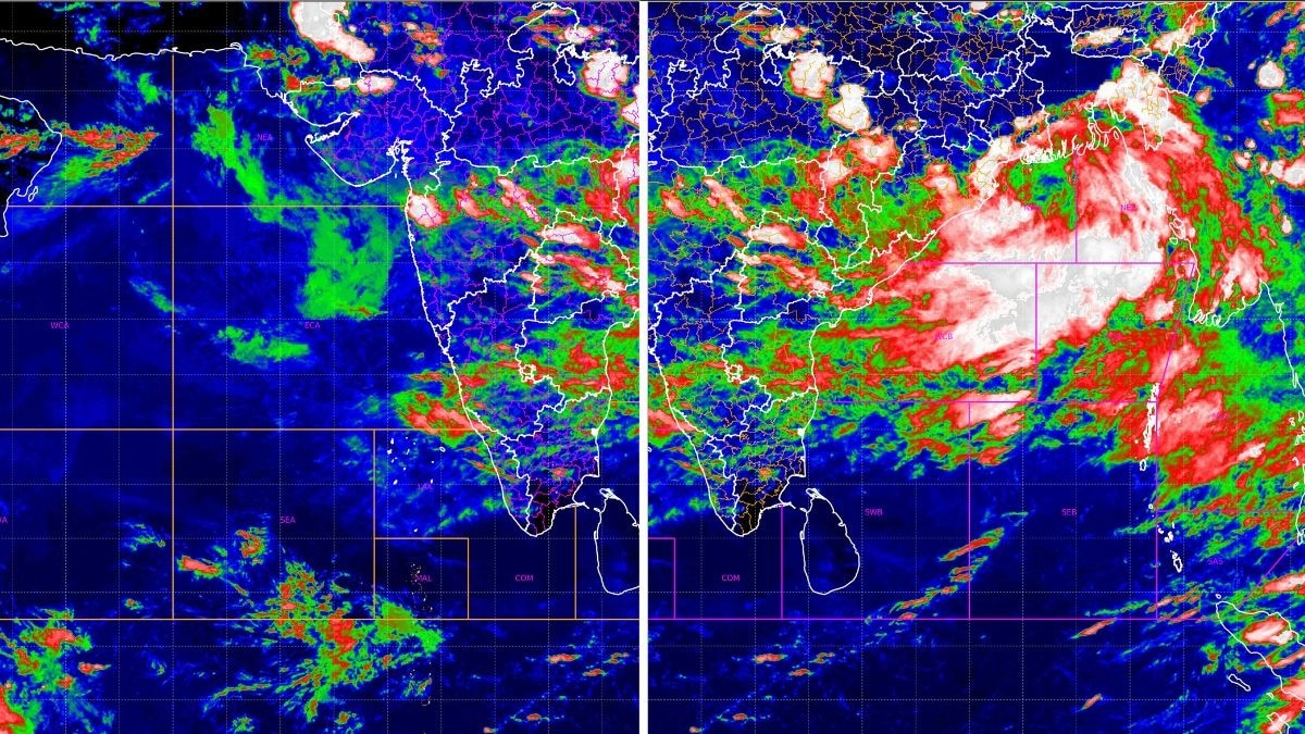
There is a kind of photograph that never shows a face. It is taken from far above the Earth by a satellite that reads the world not in ordinary light but in temperature. Set two of them side by side, one looking west over the Arabian Sea and one east over the Bay of Bengal, both caught in the same afternoon light of July 26, and you can watch the Indian monsoon work as a single machine: a storm gathering its strength in one sea while the other quietly hands it the fuel.On the ground, that machine already has a number. In the 24 hours to the morning of July 26, Jagatsinghpur in Odisha collected 33 centimetres of rain, roughly a third of a metre of water falling out of the sky in a single day.Both images come from the Indian Space Research Organisation (Isro)'s INSAT-3DR, India's weather sentinel in space, reading the sky in one narrowband of infrared light at 10.8 micrometres. This is thermal infrared, a wavelength no eye can register, but the satellite feels as heat. What it truly measures is how cold the top of each cloud is.And in the atmosphere, cold means tall. The colder a cloud top, the higher it has climbed, and the harder it is raining beneath. Deep blue is warm and quiet. White is the coldest of all, storm towers that have punched to the roof of the sky, some 14 to 16 kilometres up, where the air sinks below minus 70 degrees Celsius. Read that way, the two seas tell one connected story.THE VIEW EAST: A DEPRESSION FINDS ITS CENTRETurn first to the Bay of Bengal. Here, the cloud has collapsed into a single dense mass of brilliant white, the coldest tops in either frame, sprawled across the northwest and west-central Bay of Bengal off the Odisha and West Bengal coasts. Those palest patches mark cloud tops below minus 70 degrees, the fingerprint of cumulonimbus towers reaching the very top of the atmosphere. This is a monsoon depression, centred in the morning of July 26 near 20.6 degrees north and 88.4 degrees east, about 130 kilometres off West Bengal’s Sagar Island. The pale central dense overcast over the northwest Bay marks the deepest convection, where storm towers reach the roof of the troposphere. (Photo: IMD/ISRO) The IMD expects it to deepen into a deep depression and cross the north Odisha and West Bengal coasts, between Paradip and Sagar Island, around the forenoon of July 27.That white heart is what forecasters call a central dense overcast, the pale, near-solid shield of storm cloud that crowns a mature system, and around it, the bands have begun to curl inward, the signature of air spiralling toward a low centre and rising.A long convective arm reaches southwest from the core, dragging moisture deep inland over Chhattisgarh, Jharkhand and eastern Madhya Pradesh. The rain shield has arrived over land before the centre has, which is how a depression announces itself.THE VIEW WEST: THE SEA THAT FEEDS THE STORMNow, the Arabian Sea. There is no rival whirlpool here, no closed white spiral over open water. What the western frame shows instead is the machinery of supply.Long cloud streets run from the Somali coast across the sea toward India, the signature of a vigorous southwesterly monsoon flow. A broad plume of moisture pushes into Gujarat and Saurashtra.Heavy convection stacks up along the Konkan, Goa, coastal Karnataka and Kerala, where the moist wind slams into the Western Ghats and is forced upward. Far to the south, a band of cold clouds flares along the equator, the cross-equatorial surge that recharges the whole system. A long convective arm sweeps southwest from the depression over the Bay of Bengal, carrying moisture deep into Chhattisgarh, Jharkhand and Madhya Pradesh. (Photo: IMD/ISRO) This is the Arabian Sea doing its real job: not storming, but breathing moisture inland. That moisture feeds the season's second system, a low over west Rajasthan and its neighbourhood, whose circulation leans out toward the northeast Arabian Sea to draw the humid air in over Gujarat.Between the two systems runs the connective tissue of the whole event, an east-west shear zone near 23 degrees north, embedded with the circulations of both lows and strung across central India through the lower and middle atmosphere.A shear zone is a line where the winds aloft change direction sharply with height, forcing air to lift, cool and condense. It is the wire that ties a storm in the east to a sea in the west, writing a single rain-bearing sentence across the country's waist.WHAT A MONSOON DEPRESSION ACTUALLY ISOf the two, the Bay system is the heavyweight. A monsoon depression is the workhorse of the Indian rains, broader and less tidy than a cyclone but far more generous with water.It is born over the warm head of the Bay, where the sea holds above 28 degrees Celsius, warm enough to load the air with vapour. As that moist air rises, the vapour condenses and releases latent heat, the hidden warmth stored when water first turned to gas. The two systems are tied together by an east-west shear zone near 23°N, linking the Bay depression to the west Rajasthan low. (Photo: IMD/ISRO) That heat warms the column, lowers the pressure further, and feeds the spin. The system becomes its own engine.Unlike a cyclone, a depression does not stall at sea. It is steered inland by the monsoon trough, the long belt of low pressure that runs from the Thar Desert to the Bay, and it walks slowly west-northwest across the country, raining hardest to the south and west of its centre. This is why a single Bay depression can soak half of India.THE INLAND MARCH, AND THE RAIN THAT FOLLOWSWatch where the wire leads. As the depression moves inland, the western arm of the monsoon axis is expected to swing north over the plains, laying a corridor of low pressure towards the capital.The IMD expects fairly widespread rain over Delhi, Haryana, Chandigarh, Punjab, Uttarakhand and Himachal Pradesh in the closing days of the month, with Delhi's temperature sliding into the low thirties as the clouds close in.Closer to the core, Odisha, Chhattisgarh and Gangetic West Bengal face isolated extremely heavy falls, and the spell is expected to run across Jharkhand, Madhya Pradesh and Maharashtra. As the axis finally settles and the Arabian Sea feed strengthens again, the rain should build once more over Gujarat.The warnings are already stark. The IMD has flagged a low to moderate flash-flood risk across parts of Odisha and Chhattisgarh, and squally winds over the north Bay are set to strengthen to 55 to 65 kilometres an hour, gusting to 75, from the morning of July 27. Fishermen have been told to stay off the northwest Bay until July 29. Near the equator, a band of cold clouds marks the cross-equatorial surge that recharges the southwest monsoon over the Arabian Sea. (Photo: Windy) Where do the two systems sit right now? To summarise, the monsoon depression, the heavyweight, is parked over the northwest Bay of Bengal near 20.6 degrees north and 88.4 degrees east, roughly 130 kilometres off Sagar Island, its vortex spiralling up to 9.4 kilometres high.Its twin sits far inland, a low over west Rajasthan and its neighbourhood, a shallower vortex reaching about 5.8 kilometres, leaning toward the north Arabian Sea for moisture.Between them, an east-west shear zone near 23 degrees north strings both vortices across central India. One storm in the east, one over the western desert, one drenched country.Two seas, one afternoon. Look east, and you see the storm; look west, and you see what is feeding it. The satellite never saw a single drop of rain. It felt only the cold, and the cold told it everything.- EndsPublished By: Radifah KabirPublished On: Jul 26, 2026 18:54 IST
How Bay of Bengal and Arabian Sea twin vortices will drench India till July end
Full Article
Original Source
Read the full article at Indiatoday →KhanList aggregates and links to publicly available news content. We do not host full articles from third-party sources. Always verify important information with original sources.