
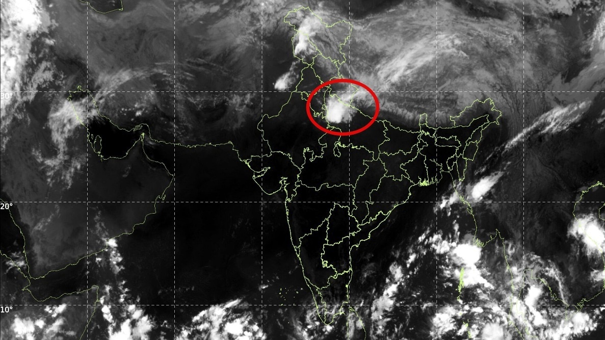
Heavy rain and thunderstorms swept across Delhi-NCR on Monday after overnight gusty winds and showers. The IMD linked the downpour to a Western Disturbance, underscoring that post-monsoon systems can still trigger disruptive weather.The IMD linked the downpour in Delhi-NCR to a Western Disturbance.Delhi-NCR woke up to heavy rain and thunderstorms on Monday after a spell of gusty winds and showers began late Sunday night and spread across much of the region.From Delhi and Gurugram to Noida, Faridabad and Ghaziabad, intense rainfall brought a sudden change in weather, with more thundershowers expected in several areas.Safdarjung, Delhi’s primary weather observatory, recorded 40 mm of rainfall till 5.30 am, according to the data provided. The India Meteorological Department (IMD) had warned of heavy rain and thunderstorms across parts of northwest India, even though the southwest monsoon has withdrawn from several regions.WHAT DOES THE SATELLITE IMAGE SHOW?The INSAT-3DS thermal infrared image captured between 8.30 am and 8.57 am on Monday shows extensive cloud cover over northern India, including a broad cloud band stretching across parts of the Himalayan region and adjoining plains. Brighter white areas in this infrared image generally indicate colder cloud-top temperatures. These can be associated with high, deep clouds capable of producing thunderstorms, although the image alone cannot confirm rainfall intensity at a particular location.The cloud pattern is consistent with an active weather system affecting northwest India, with rain-bearing cloud bands extending towards the Delhi-NCR region.WESTERN DISTURBANCE IS DRIVING THE RAIN The primary trigger is a Western Disturbance, a weather system that travels eastwards from the west and can bring rain, thunderstorms and hail to northwestern India.According to the IMD’s October 11 bulletin, a Western Disturbance was present as a cyclonic circulation over Himachal Pradesh. Additional atmospheric troughs extended from northwest Rajasthan towards northeast Madhya Pradesh, while another connected a circulation over central Pakistan with north Madhya Pradesh.These systems can encourage air to rise, allowing clouds to develop when sufficient moisture and atmospheric instability are present.Fresh cloud bands extending from central Haryana are helping sustain the showers over the plains. As these bands move across the region, different parts of Delhi, Gurugram, Noida, Faridabad and Ghaziabad can experience spells of moderate to heavy rain and thunderstorms.WILL THE RAIN CONTINUE?The IMD issued a warning for heavy rain, thunderstorms and gusty winds over Delhi on Monday morning, while orange warnings covered several adjoining districts in Haryana and Uttar Pradesh.The rainfall may cause waterlogging, traffic disruption and reduced visibility.The episode also highlights an important distinction: monsoon withdrawal does not mean the end of rainfall. Western Disturbances and other weather systems can produce heavy rain after the seasonal monsoon retreats.In Delhi-NCR, the current downpour is being driven by these post-monsoon atmospheric disturbances rather than a return of the southwest monsoon.- Ends
Gusty winds, heavy rain: What's behind the sudden downpour in Delhi-NCR?
Full Article
Original Source
Read the full article at Indiatoday →KhanList aggregates and links to publicly available news content. We do not host full articles from third-party sources. Always verify important information with original sources.