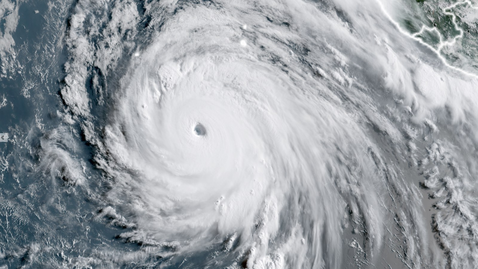
Intensifying at a dramatic pace, Hurricane Genevieve – which was nothing more than a tropical depression on Friday, July 24 – became the first Category 5 storm of 2026 in the Eastern Pacific at 5 a.m. EDT Monday, July 27, with top sustained winds touching 160 mph (257 km/hr) and a central pressure of 925 mb. As of 11 a.m. EDT Monday, Genevieve’s top sustained winds had dropped slightly to 155 mph (251 km/hr), which put the hurricane back in the Cat 4 range – albeit at the very top of that range. Genevieve is the first Eastern Pacific storm to hit Cat 5 status since Kristy in 2024. Fortunately, Genevieve’s wrath is playing out far away from land. As of 11 a.m. EDT Monday, Genevieve was centered roughly 520 miles south-southwest of the southern tip of Baja California. Genevieve was moving northwest, roughly parallel to the Pacific coast of Mexico, at a brisk 14 mph. Steady steering currents are predicted to keep Genevieve well clear of any land areas over the next five days. The track is forecast to take a slight leftward bend over time, moving it even farther away from land. Contributing to Genevieve’s rapid ascent to Cat 5 strength were light-to-moderate wind shear, a moist atmosphere (relative humidity above 80%), and sea surface temperatures of around 30 degrees Celsius (86 degrees Fahrenheit). The waters of the tropical Eastern Pacific from Genevieve west to the region south of Hawaii are experiencing near-record warmth for late July. This area lies just north of the Niño3.4 region that straddles the equator, where records for late-July oceanic warmth are getting pulverized – courtesy of the record-early onset of a powerful El Niño event. As Genevieve took shape, it drew on a ribbon of exceptionally moist air extending from the Niño3.4 region, and this likely helped nurture the storm’s rapid growth. Figure 1. Sea surface temperatures over the eastern North Pacific between latitudes 10 and 25 degrees north and longitudes 124 and 170 degrees west as of Friday, July 25, 2026. Genevieve reached hurricane strength just after entering this region on Saturday and is predicted to continue moving through the region all week. (Image credit: University of Arizona, based on NOAA OISST data) Forecast for Genevieve Genevieve is predicted to suffer the classic slow demise typical of powerful hurricanes moving west-northwest through the tropical Eastern Pacific. In this part of the world, hurricane-supportive oceanic warmth does not usually extend into the subtropics, as it often does in the western Atlantic. Sea surface temperatures beneath Genevieve’s path are predicted to drop below 25°C (77°F) by Thursday, falling below the standard 26°C threshold for hurricane sustenance. Genevieve will also be moving into increasingly dry air, with midlevel relative humidity dropping to around 50% by late week. Given these conditions, the NOAA/NWS National Hurricane Center predicts that Genevieve will steadily weaken, likely falling below hurricane strength by around Friday. Genevieve is the planet’s fourth Category 5 tropical cyclone of 2026. The others to date: Tropical Cyclone Horacio, 160 mph (260 km/h) winds, February 23, over the remote South Indian Ocean. Horacio did not affect any land areas. Super Typhoon Sinlaku, 185 mph (295 km/hr) winds, April 12, southeast of Guam. Sinlaku made landfall over the U.S. Northern Mariana Islands on April 14, with the large eye of the storm passing over both Tinian and Saipan islands simultaneously. According to the Joint Typhoon Warning Center, Sinlaku was a Cat 4 with sustained winds of 145 mph (230 km/hr) at landfall. Sinlaku killed 17 and did about $1.5 billion in damage to the Northern Mariana Islands and Guam. Super Typhoon Bavi, 180 mph (285 km/h) winds, July 5, a long-track typhoon over the northwest Pacific. Bavi struck the island of Rota in the U.S. Northern Mariana Islands at peak intensity, then weakened gradually before a second landfall near Zhejiang, China, on July 11, this time as a tropical storm. Damage of more than $140 million extended across a number of Northwest Pacific islands as well as parts of East Asia, and at least 23 people were killed. Bavi was the 11th Category 4 or 5 tropical cyclone to hit a U.S. state or territory in the past 10 years; that’s as many Cat 4 and Cat 5 landfalls as the U.S. Gulf and Atlantic coast suffered over the prior 60 years. Squalls and swells from a weakening Fausto to affect northern and eastern Hawaii Tracking well ahead of Genevieve, on a path that’s similar but displaced a bit farther south, Hurricane Fausto is en route to pass just north of the Hawaiian islands on Tuesday and Wednesday. Hurricane Fausto has continued moving quickly toward the west. It was officially named on July 19 and became a hurricane on July 20 over the warm waters of the Pacific Ocean. By Friday morning Hawaii Standard Time, Fausto reached Category 2 intensity, peaking with maximum sustained winds of 105 mph (165 km/h). Throughout last week, Fausto traveled over warm waters while maintaining a fairly symmetrical wind field. By Saturday, however, dry air began infiltrating the system. Fausto gradually weakened through Saturday and Sunday while maintaining its hurricane status. By Monday morning Eastern Time, Fausto was a Category 1 hurricane with maximum sustained winds of 85 mph (140 km/h). The system continues moving west at about 15 mph (24 km/h). Figure 2. 0Z Monday run of the European model shows Fausto passing 50-100 miles (80-160 kilometers) north of Oahu and Molokai at midday local time on Wednesday, July 29. (Image credit: TropicalTidbits.com) As Fausto continues to weaken, it is forecast to be downgraded to a tropical storm as it encounters increasingly dry air and cooler sea surface temperatures. Current forecasts indicate that by Tuesday night into Wednesday morning local time, the center of Fausto should be just northeast of Honolulu, passing at a safe distance from the northern portion of the Hawaiian Islands. The latest forecast track from the National Hurricane Center shows that by Wednesday afternoon, the center of Fausto should pass about 80 miles (128 kilometers) north of Honolulu. Tropical-storm-force winds are predicted to extend only about 50 m (80 km) southward from Fausto by that point. Figure 3. Fausto’s official track by the NHC, released on Sunday, July 26, 2026 at 11 p.m. EDT. It shows that Fausto will remain at a safe distance from the island as a tropical storm. (Image credit: NHC) The primary factor contributing to Fausto’s weakening is the cooler sea surface temperatures. Fausto had been traveling over waters warmer than 80°F (27°C), but as of Monday, it is expected to move over waters closer to 77°F (25°C). These cooler waters will reduce the energy available to the hurricane, further weakening the system. Figure 4. Sea surface temperatures around Hawaii drop significantly to the north of the islands to below 78°F (25.8°C), which would put a dent in Fausto, causing the storm to downgrade to tropical storm status. (Image credit: NOAA) As with any tropical cyclone, the center of the storm could wobble over the next couple of days, leading to slight variations in its forecast track. In addition, increasing wind shear will continue to displace Fausto’s strongest thunderstorms and winds to the north of the storm’s center. This means the Hawaiian Islands should be spared from most of Fausto’s heavy showers and thunderstorm activity. Figure 5. Fausto is predicted to weaken further through the first half of the week, likely becoming a remnant or a trough of low pressure by the end of the week. (Image credit: Cyclonicwx.com/Alex Boreham) Nonetheless, despite the storm’s asymmetrical structure, the eastern and northern portions of the islands could still experience gusty winds and very high surf. East-facing shores are expected to see increasing seas, with surf potentially reaching high surf warning criteria between Monday night and early Wednesday. Some east-facing beaches could experience surf heights of 10 to 14 feet beginning Monday night. By Tuesday night, as Fausto is forecast to move north of the islands, north-facing shores could see surf heights of 12 to 15 feet. Tropical Storm Warnings remain in effect for the open waters surrounding the entire Hawaiian island chain. However, the islands themselves are not under any tropical storm warnings or watches. High surf advisories and small craft advisories are in effect and will likely remain in place through the middle of the week. Figure 6. A Tropical Storm Warning was in effect across the open waters surrounding Hawaii on Monday morning HST, while high surf and small craft advisories surrounded the coastal areas of Hawaii (Image credit: NOAA) As Fausto moves away, some rain bands may continue to move across the Hawaiian islands from east to west. If these rain bands linger over the same locations for an extended period, isolated flooding could occur in a few areas. Watching Dolphin: Another Cat 5 storm could develop in the Pacific late this week Far west of Hawaii, yet another tropical cyclone – newly named Tropical Storm Dolphin – is expected to become a formidable typhoon. Dolphin is predicted by the Joint Typhoon Warning Center to strengthen steadily over the next several days. In an unusually aggressive forecast late Sunday night, the center predicted Dolphin to reach Category 5 strength by late this week, as it moves amid light wind shear and favorable upper-level outflow over a part of the open northwest Pacific where sea surface temperatures are running 1-2°C (2–4°F) warmer than average. Dolphin is expected to avoid land areas, tracking well northeast of the U.S. Mariana Islands and south of Wake Island. As for the Atlantic Ocean, no tropical cyclones of any consequence are expected over at least the next week, as hostile conditions typical of El Niño are ruling the roost. Jeff Masters contributed to this post. Republish our articles for free, online or in print, under a Creative Commons license.
Genevieve becomes the first Category 5 hurricane of 2026
Full Article
Original Source
Read the full article at Yaleclimateconnections →KhanList aggregates and links to publicly available news content. We do not host full articles from third-party sources. Always verify important information with original sources.