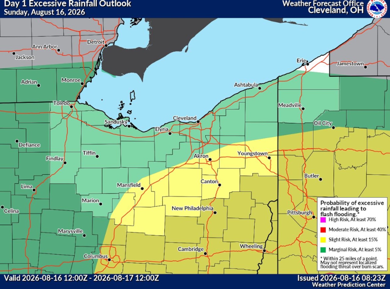
WeatherThe National Weather Service says there's a chance of excessive rainfall on Sunday in northern Ohio.National Weather ServiceBy Adam Ferrise, cleveland.comcleveland.com Express DeskCLEVELAND, Ohio — The National Weather Service has canceled the flood watch that was previously in place, but scattered thunderstorms expected this afternoon and evening could still bring heavy rain and localized flash flooding. No active weather watches or warnings are currently in effect for Cleveland, Cuyahoga County or surrounding counties.A mesoscale convective vortex, or MCV, is moving through the region and producing scattered showers this morning. The system is expected to move east by sunrise, and limited atmospheric instability should keep the risk of significant flooding low through the morning.More showers and thunderstorms are expected to develop this afternoon, first near Toledo before spreading east across northern Ohio. A few storms south of Lake Erie could become strong to severe and produce damaging wind gusts, forecasters said.The storms also could bring heavy rainfall rates and a chance of localized flash flooding. Extremely humid conditions, with dew points in the low to mid-70s, will provide plenty of moisture for downpours.The storms are expected to move through fairly quickly, which should limit the risk of widespread flooding. But urban areas and places that have already received heavy rain in recent days could still see localized flooding.Scattered showers could linger Sunday night into Monday morning across northeast Ohio and northwest Pennsylvania before conditions gradually improve.Winds will shift to the southwest today and increase to around 10 mph by the afternoon. Gusts could reach 20 mph during the afternoon and early evening, particularly near Toledo and Mansfield. Thunderstorms could produce even stronger, more variable wind gusts.Looking ahead, another round of showers and thunderstorms is expected Wednesday as a cold front moves southeast across northern Ohio. The National Weather Service is forecasting a 60% to 80% chance of rain across the area, especially during the afternoon.Some severe weather also could develop Wednesday, although forecasters are still uncertain how much atmospheric instability will be available for storms to work with.On Lake Erie, winds will shift from the southwest at 10 to 15 mph today to northwesterly behind the front by early Monday. Winds will become light and variable late Monday into early Tuesday before shifting back to the southwest Tuesday evening and continuing into early Wednesday. No marine headlines are currently expected over the next several days.Overall, the weather pattern is expected to remain unsettled through the middle of the week, with periods of heavy rain and thunderstorms possible before conditions improve Thursday.Adam Ferrise covers federal courts for cleveland.com and The Plain Dealer, where he’s worked since 2013. He previously covered Cleveland crime and policing, Akron and Summit County crime and courts and crime in...This article was produced with assistance from AI tools and reviewed by Cleveland.com staff.
Flood watch canceled, but afternoon storms could bring localized flooding to northern Ohio
Full Article
Original Source
Read the full article at Cleveland →KhanList aggregates and links to publicly available news content. We do not host full articles from third-party sources. Always verify important information with original sources.