
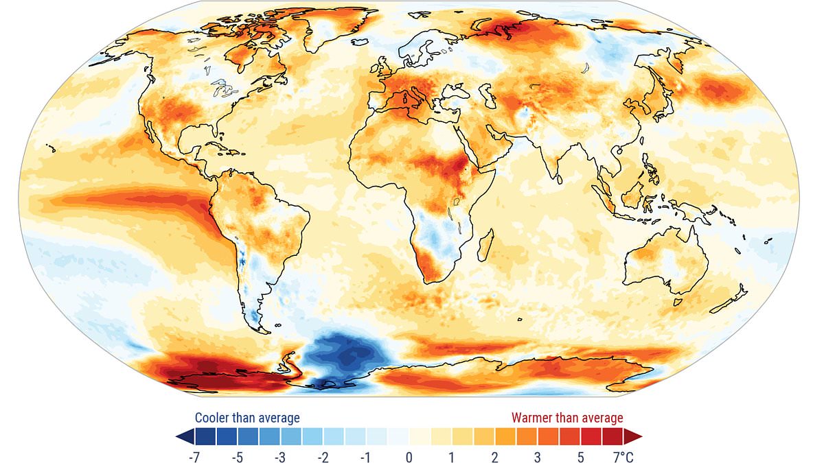
Earth is on track for its hottest year on record after a brutal summer of extreme temperatures, experts say.Global average temperatures for the first eight months of the year are already 1.22°C (2.2°F) above the average baseline.At this rate, 2026 is on track to become the second warmest year in recorded history – coming in just behind 2024.However, meteorologists now say that average temperatures are set to soar in the last few months of the year.According to experts at AccuWeather, this will likely make 2026 the hottest year ever recorded.This lingering heat is partly being driven by the looming Super El Niño, which has driven up ocean surface temperatures in the equatorial Pacific.As that build-up of heat begins to spread around the globe, temperatures will rise to new highs.But with El Niño not expected to reach its peak until late December or January, experts warn that 2027 is likely to be even hotter still. Earth is on track for its hottest year on record after a brutal summer of extreme temperatures, experts say. Pictured: Temperatures relative to the monthly average for August This comes after a summer which has shattered temperature records all over the world.The latest data from the Copernicus Climate Change Service shows that August 2026 was the warmest August on record.With an average surface air temperature of 16.82°C (62.27°F), this was 0.85°C (1.53°F) above the average for 1991 to 2020.This August also tied for the hottest month ever measured globally, matching a record set during the extreme summer heatwave of July 2023.Unusually, August 2026 was actually 0.1°C (0.18°F) hotter than July, which is usually the hottest month of the year. Tyler Roys, expert meteorologist at AccuWeather, says: 'What stands out is how widespread and persistent the warmth has been, from the atmosphere to the oceans.'Now we’re seeing a rapidly strengthening El Niño developing on top of that unusually warm global background. That combination could have significant implications for weather patterns around the world through the fall and winter.'El Niño is part of a naturally occurring climate cycle called the El Niño Southern Oscillation, which flips between hot and cold phases once every two to seven years. This follows Europe's hottest summer on record, passing a benchmark last set in 2003 (illustrated) Scientists have previously warned that El Niño is 'firmly established' and 'being supersized before our eyes' as temperatures continue to rise The hottest years on record 2024: +1.29°C (+2.32°F) above average2026*: +1.22°C (+2.20°F) above average 2025: +1.19°C (+2.14°F) above average2023: +1.17°C (+2.11°F) above average2016: +1.01°C (+1.82°F) above average*Data as of August During the hot, El Niño phase, the trade winds that normally carry warm waters away from South America towards Australia slow or even reverse.This prevents cold water from welling up and leads to a buildup of hot water near the surface in the equatorial and tropical Pacific Ocean.Experts warn that climbing ocean temperatures are already threatening extreme conditions, as that trapped heat spreads from sea to land.Outside of the polar regions, the average sea surface temperature in August hit 21.07°C (69.93°F), the hottest on record for the month and the joint hottest month ever recorded.This was also highly unusual since sea surface temperatures typically reach their peaks in March, suggesting that El Niño is already having profound consequences.According to the Met Office’s latest predictions, warming in the Pacific could reach 3°C (5.4°F), while some reports project an increase as high as 4°C (7.2°F).That means temperatures are likely to continue climbing as the Super El Niño reaches its peak around the start of 2027.'In many ways, this story is just getting started,' says Mr Roys. As sea surface temperatures continue to rise due to El Niño, experts say that next year is on track to be even hotter than 2026'El Niño is still rapidly strengthening and can reshape the jet stream and shift storm tracks, rainfall and temperature patterns across large portions of the globe. 'The impacts of this event could extend well beyond the Pacific in the months ahead.'Forecasts indicate an 'exceptionally huge likelihood of nearly 100 per cent' that El Niño will cause problems until February – the first time such an unequivocal update has been issued.In the UK, El Niño is likely to make autumn and early winter colder, wetter and stormier, according to the Met Office. As the Super El Niño weather event ramps up, Brits have even been urged to stockpile food in preparation for extreme weather. Dame Angela Eagle, Secretary of State for Environment, Food and Rural Affairs (Defra), told The Guardian: 'If you've got a store of a bit of food that can keep you going for a while before the emergency services can get to you, you're going to be a lot better off than if you haven't.'WHAT IS THE EL NINO PHENOMENON IN THE PACIFIC OCEAN?El Niño and La Niña are the warm and cool phases (respectively) of a recurring climate phenomenon across the tropical Pacific - the El Niño-Southern Oscillation, or ENSO for short.The pattern can shift back and forth irregularly every two to seven years, and each phase triggers predictable disruptions of temperature, winds and precipitation. These changes disrupt air movement and affect global climate. ENSO has three phases: El Niño: A warming of the ocean surface, or above-average sea surface temperatures (SST), in the central and eastern tropical Pacific Ocean. Over Indonesia, rainfall becomes reduced, while rainfall increases over the tropical Pacific Ocean. The low-level surface winds, which normally blow from east to west along the Equator, instead weaken or, in some cases, start blowing the other direction from west to east. La Niña: A cooling of the ocean surface, or below-average SST, in the central and eastern tropical Pacific Ocean. Over Indonesia, rainfall tends to increase, while rainfall decreases over the central tropical Pacific Ocean. The normal easterly winds along the Equator become even stronger.Neutral: Neither El Niño or La Niña. Often tropical Pacific SSTs are generally close to average.Source: Climate.gov
Earth is on track for the hottest year on record, experts say - amid warnings Super El Niño could send temperatures soaring even higher in 2027
Full Article
Original Source
Read the full article at Dailymail →KhanList aggregates and links to publicly available news content. We do not host full articles from third-party sources. Always verify important information with original sources.