
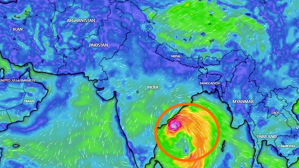
Cyclone Arnab is bearing down on India's eastern coast, bringing the Bay of Bengal's powerful storm season into focus.The very severe cyclonic storm was positioned over the west-central Bay on Tuesday, October 27, with the India Meteorological Department (IMD) forecasting landfall along the Andhra Pradesh coast by Wednesday morning.But why does the Bay of Bengal produce so many cyclones?The answer lies in a combination of warm seawater, moisture, wind patterns and the region's seasonal weather. Together, these conditions make the Bay particularly favourable for storms to form and intensify. WHY DOES THE BAY OF BENGAL PRODUCE SO MANY CYCLONES?The Bay of Bengal is historically more cyclone-prone than the Arabian Sea.The IMD estimates that the frequency of tropical cyclones in the Bay is about four times that in the Arabian Sea, although the numbers vary across years and seasons. Warm water is one of the biggest reasons.Tropical cyclones draw energy from warm ocean surfaces, where water evaporates and rises into the atmosphere. As this moist air cools, it forms clouds and releases heat, helping the storm grow. A satellite image shows Cyclone Arnab churning in the Bay of Bengal. (Photo: IMD) The Bay also receives enormous amounts of freshwater from rainfall and major rivers, including the Ganga and Brahmaputra. This freshwater makes the surface layer less salty and helps it remain separate from cooler water below.As a result, strong winds are less likely to mix cooler water up to the surface, allowing the ocean to continue supplying heat to a developing storm.HOW WINDS HELP STORMS GROWWarm water alone cannot create a cyclone as for a storm to be born, the atmosphere must also cooperate.When winds at different heights blow in very different directions or at different speeds, they can tilt and disrupt a developing storm. This is known as wind shear. Rough sea conditions prevail ahead of the Arnab's landfall, in Visakhapatnam, Andhra Pradesh. (Photo: PTI) When this disruption is weaker, a cyclone has a better chance of organising itself and strengthening.The Bay of Bengal often experiences conditions that favour this process, while seasonal weather disturbances can provide the initial trigger for storm development.WHY ARE OCTOBER AND NOVEMBER IMPORTANT?Cyclones in the north Indian Ocean typically have two main seasons; April to June and October to December.The post-monsoon period is particularly active over the Bay of Bengal, as the monsoon retreats and conditions again become favourable for storm formation.Last 24-hours rapid intensification of Cyclone Arnab into a dangerous intense storm. The Bay of Bengal has a long history of very intense cyclones. Hopefully everyone can get out of the path of this powerful cyclone. https://t.co/Mpi6IzoN0R— Ryan Maue (@RyanWeather) October 27, 2026The Arabian Sea also produces dangerous cyclones, and its activity has increased in some recent years.The Bay's historical dominance does not mean every storm will form there or that every cyclone will become severe.With Cyclone Arnab approaching the coast, the seasonal pattern is once again in focus. Warm seas provide the fuel, but the atmosphere determines whether that energy develops into a powerful storm.- Ends
Cyclone Arnab roaring: How Bay of Bengal churns massive storms repeatedly
Full Article
Original Source
Read the full article at Indiatoday →KhanList aggregates and links to publicly available news content. We do not host full articles from third-party sources. Always verify important information with original sources.