
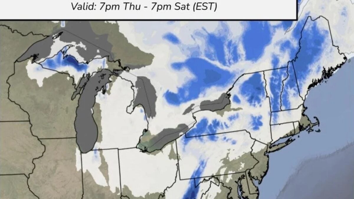
After weeks of warmer-than-average weather, millions across the eastern U.S. could get an early taste of winter this week. A surge of cold air and developing storms are poised to bring high winds, frigid temperatures, rain, and potentially accumulating snow to parts of the Mid-Atlantic and Northeast. Thanks to a deep dip in the jet stream, an intrusion of cold air from Canada will send temperatures plummeting across the eastern half of the country by late Wednesday or Thursday morning, according to the National Weather Service. Between Wednesday and Friday, forecasters at The Weather Channel expect daytime highs to plunge 20 degrees Fahrenheit (11 degrees Celsius) from Chicago to Atlanta. Enjoy the milder temperatures across the East because colder air is on the way 🥶. The next storm system will usher in high temperatures in the 40s and 50s, along with rain and blustery conditions. pic.twitter.com/y33xbgbTPu — NWS Weather Prediction Center (@NWSWPC) November 10, 2026 Meanwhile, a developing storm system will migrate from the northern Plains into the Appalachians, intensifying and expanding to bring high winds to much of the eastern U.S. by Thursday morning. When the storm meets the surge of cold air, rain could turn to wintery precipitation. The upper Great Lakes could see wet snow by Thursday morning, NWS forecasters say. By Thursday night, a nor’easter may form off the Eastern Seaboard, The Weather Channel reports. That system could bring a wintery mix or snow to the Mid-Atlantic and New England over the weekend. How much snow could fall, and where? Those are the big questions right now. The forecast is still solidifying, so expected snowfall totals and locations are still largely uncertain. However, the NWS has produced a map showing where at least 1 inch (2.5 centimeters) of snow is most likely to fall between Thursday and Saturday. You may have heard there is a threat for snow in the Northeast/Mid-Atlantic late this week. Here is the latest information on that possibility. Please stay weather aware at https://t.co/D8jZlzOsbd for the latest on the storm! pic.twitter.com/KDBSQo5fh1 — NWS Weather Prediction Center (@NWSWPC) November 9, 2026 Large swaths of New York, Vermont, New Hampshire, and Maine can expect snow, as well as the Upper Peninsula of Michigan and a narrow band of eastern West Virginia. Elsewhere across the Northeast and East North Central Midwest, snowfall chances remain low, but it’s not out of the question. Snow will be most likely to accumulate at higher elevations, so the storm could bring an early-season boost to ski mountains in the Northeast. At the very least, below-freezing temperatures will assist snowmaking. Snow totals will depend not only on storm intensity but also on speed. CNN meteorologists explain that a faster-moving storm would lead to less accumulating snow because precipitation would spend less time in the cold air and would fall over a shorter duration. As of now, forecast models are still disagreeing on storm speed and track. What about El Niño? This forecast may come as a surprise to those who have been keeping up with this rapidly strengthening El Niño. The recurring climate phenomenon tends to bring milder winter conditions to the northern tier of the United States, so why are we expecting frigid cold and snow in mid-November? Well, El Niño won’t be the only force shaping weather in the northern U.S. this winter. When the jet stream dips southward over the U.S. like it is now, Arctic air spills southward with it. This creates a sharp contrast between cold temperatures in northern states and warmer air farther south that can add fuel to developing storm systems. As those systems move along the jet stream, they can dump wintery precipitation where temperatures are low enough. So while it’s possible that El Niño could lead to a milder winter for the northern U.S. overall, that doesn’t mean this half of the country won’t experience periods of severe cold and storms this season. In fact, forecasters expect the polar vortex to undergo an unprecedentedly early disruption this month, which means more frigid weather could be in store for the end of November and early December. For now, however, all eyes are on this weekend’s forecast. Temperature and precipitation outlooks should come into sharper focus over the next few days, so be sure to monitor what’s expected in your area.
Break Out the Shovels—a Nor’easter May Bring the Northeast’s First Snow This Week
Full Article
Original Source
Read the full article at Gizmodo →KhanList aggregates and links to publicly available news content. We do not host full articles from third-party sources. Always verify important information with original sources.