
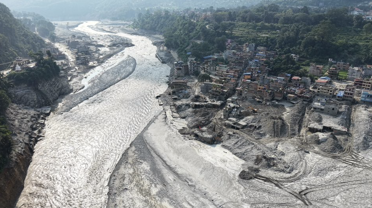
Extreme flooding events like we’ve witnessed recently in Nepal can shift ecosystems and wildlife populations, while also threatening programs that mitigate climate change.Two experts argue that what’s needed are more regular post-event assessments of vegetation loss, changes in aquatic biodiversity and shifts in types and numbers of wildlife, all of which can be tied into existing data sources available from satellite monitoring programs, for example.“Looking at what followed those events gives us some clues about what may now be unfolding in Nepal and the wider Hindu Kush Himalaya region, and what this could mean for conservation, restoration and climate policy,” they write.This article is a commentary. The views expressed are those of the authors, not necessarily of Mongabay. In less than seven weeks, two major flood events impacted Nepal’s Himalaya, where ecologically rich mountain landscapes are closely connected to the rivers, forests and floodplains. On the morning of Aug. 26, 2026, a catastrophic flood began with a rock and ice collapse on the northern flank of Langtang Lirung, within Langtang National Park. The park is one of country’s major Himalayan protected areas and provides habitat for species like Himalayan musk deer (Moschus leucogaster), Asiatic black bear (Ursus thibetanus), red panda (Ailurus fulgens) and clouded leopard (Neofelis nebulosa). Then, on Oct. 11, another destructive flood occurred in the Budhi Gandaki basin after a landslide blocked the river near Chumchet village in Gorkha District within the Manaslu Conservation Area that supports snow leopard (Panthera uncia), musk deer, blue sheep (Pseudois nayaur) and Himalayan tahr (Hemitragus jemlahicus), along with more than 200 recorded Himalayan plant species. While the human cost of these disasters and the damage to physical infrastructure have been reported extensively, much less attention has gone to what they are doing to ecosystems and wildlife in the region. In the Himalaya, because of the extraordinary diversity and interconnectedness, any disturbance created in a high mountain valley can affect forests, wetlands and floodplains much further downstream. Some of the immediate effects are already visible after the recent events, but their ecological and longer-term consequences require systematic assessment. Research on earlier Himalayan disasters shows that major disturbances and extreme events can gradually contribute to a broader ecological reorganization of the region. Looking at what followed those events gives us some clues about what may now be unfolding in Nepal and the wider Hindu Kush Himalaya (HKH) region, and what this could mean for conservation, restoration and climate policy. Soldiers lead a rescue operation at the site of a hydropower project in Upper Trishuli, Nepal, Monday, Aug. 31, 2026. Image courtesy of the Nepali Army. Extreme events can push ecosystems onto a different path Earlier events in parts of the HKH give some sense of how these ecological changes unfold. After the 2015 Gorkha earthquake researchers estimated that around 8,652 hectares (almost 21,400 acres) of vegetation were lost, including in protected areas. Six years later, only about half had recovered, and the vegetation cover would take at least nine years to return to its earlier level. A similar long-term effect can be seen in freshwater ecosystems. Research from Uttarakhand’s Assi Ganga found that the 2012 and 2013 extreme flooding events had wiped out both native fish populations and invasive brown trout at the study sites. More than a decade later, native snow trout (Schizothorax richardsonii) had recovered strongly, but the invasive brown trout (Salmo trutta) had also returned, while aquatic invertebrates showed only partial recovery. There are signs of this pressure at a much wider scale as well. A 2026 study looking at vegetation responses to climatic extremes found an average interannual relative vegetation loss of around 8.17% across the HKH, with much larger losses when different climatic stresses occurred together. The figure refers to vegetation productivity (rather than hectares of forest lost) but show the widespread impact of the existing pressures. These cases highlight that after major events, some species and ecological functions may return, while the wider ecosystem continues to change in composition and structure. Rishuli Bazar, Nuwakot District, showing extensive flood damage to residential buildings, hydropower infrastructure, and government facilities following the 26 August 2026 disaster, October 3, 2026. Image courtesy of Khim Lal Gautam. Ecological impacts of the recent events For the August event, some early assessments have started to show what happened beyond infrastructural damage. A rapid situation analysis found that riparian floodplains, shrubs, wetlands, river channels, sandbars and grasslands were exposed to severe disturbance. It also identified possible impacts on fish species such as the golden mahseer (Tor putitora) and snow trout. When commentary co-author Khim Lal Gautam visited the region, significant riverbed uplift was visually observed from Rasuwa Gadhi to Galchhi, where it joins the Prithvi Highway. The flood extensively changed the large sections of the river channel through erosion, sediment deposition, channel widening and riverbank collapse. High energy debris flows swiped vegetation from the banks and destroyed riparian habitats of birds, small mammals, reptiles and aquatic organisms. However, the effects of such large-scale events extend further downstream. We need to remember that, like other rivers in the region, Trishuli is part of a connected river system traversing a highly diverse ecological landscape. Chitwan National Park supports around 65% of the fish species recorded in Nepal, as well as several threatened river-dependent species. Recent flooding has already shown the risks to endangered wildlife across this connected landscape. During the separate late-September flooding of the Narayani, a 5-year-old rhino was carried downstream from the Chitwan area to Susta, and similar incidents have occurred before. Nepal’s wildlife authorities have documented floods in which rhinos were washed from Chitwan toward Susta and across the border into Bihar and later had to be rescued. Across the border, floodwater from the Gandak also entered low-lying areas of Valmiki Tiger Reserve in late September. Forest officials identified deer, wild boar and other animals in inundated areas as being particularly exposed. This also increased the possibility of human-wildlife conflict in the region. For the Oct. 11 event in Budhi Gandaki, there is not yet a comparable post-event assessment of vegetation loss, aquatic biodiversity or wildlife within the Manaslu Conservation Area. Most early reporting has focused on people, trails, bridges and other physical damage, resulting in much less information on what happened to the protected landscape itself. Betrawati Bazar at the Rasuwa-Nuwakot border, Nepal, following the catastrophic August flood that swept away much of the settlement, October 2026. Image courtesy of Khim Lal Gautam. Extreme events can also threaten climate gains Ecological damage can have implications beyond biodiversity conservation, since they can affect climate mitigation efforts that depend on forests and other ecosystems continuing to function over long periods. Recurring extreme events like floods, landslides, droughts and fires can make those efforts difficult to sustain. In many cases, the ecological reorganization may leave a landscape functioning differently from before. That essentially creates a question about the durability of climate gains. These risks are particularly relevant in the HKH, where critical biodiversity areas are exposed to several forms of environmental stress. A recent HKH-wide assessment estimates that around 13.5 to 20.5% of the region’s forested area is highly susceptible to fire, and shows some of the pressures that long-term conservation and carbon storage efforts need to account for. Nepal offers an interesting example of how these risks intersect with climate investments. For example, Chitwan is one of the 13 districts covered by the Terai Arc Landscape (TAL) emissions reduction program, which spans around 2.4 million hectares (almost 6 million acres) and works through forest protection, community forest management and reducing emissions from deforestation and forest degradation (REDD+). In November 2025, Nepal received $9.4 million for around 1.88 million tons of verified CO2 emission reductions generated through the program, its first payment under the agreement. The TAL program is not directly located in the Aug. 26 flood-affected Rasuwa–Bhote Koshi zone, so its corridors, community forests, and protected-area links were not directly destroyed. However, the flood’s downstream pathway through the Trishuli–Narayani system created indirect ecological risks for riverine habitats toward Chitwan. Even where forests themselves are not destroyed, changes in river systems, erosion, sediment movement and repeated disturbance can affect the wider ecological conditions upon which these programs depend. Further, the national emergency might divert conservation capacity away from TAL’s regular restoration, monitoring, and anti-poaching work. Map of the Terai Arc Landscape Emission Reductions Program, which spans around 2.4 million hectares. Image courtesy of WWF. Tracking ecological change after extreme events Most post-event assessments focus on immediate issues, and ecological effects are usually not reported much due to their longer response timeline and difficulty of measuring them immediately. Satellite imagery can provide an important starting point to understand the damage. After the August event, Copernicus imagery around Betrawati and Gerkhu showed a much wider river channel and large sediment deposits extending across parts of the valley floor. Imagery following the October event similarly showed new sediment deposits and changes in river channels along the Budhi Gandaki system. Observing the same locations over time could show where channels remain altered, where sediment continues to move and whether vegetation begins to return. But satellite images cannot tell us whether fish communities have changed, whether riverbanks and sandbars remain suitable for species such as gharials (Gavialis gangeticus), or whether wildlife is moving differently through the landscape. Field surveys are therefore needed alongside satellite observations, particularly in places where physical changes persist. Nepal already has some useful baselines that could help. Earlier environmental DNA research in the Trishuli recorded 24 fish taxonomic units, including migratory fish such as snow trout and mahseer. Repeating similar sampling could show how fish communities change after major disturbances, although seasonal differences, river flow and other pressures would also need to be taken into account. Chitwan also has long-running wildlife monitoring, while Nepal’s forest monitoring systems are already being used to track forest cover, degradation and deforestation in the Terai Arc landscape. Rather than creating a new monitoring system after every disaster, these existing sources could be used more closely together. If extreme events are contributing to ecological reorganization across parts of the Himalaya, recovery may not always mean returning to an earlier condition. Observing different habitats for several years, rather than only during the immediate aftermath, would give a much clearer picture of which ecosystems are recovering and where conservation approaches may need to adapt to a landscape that has itself changed. Khim Lal Gautam is chief survey officer for the Nepal Survey Department and is also a mountaineer and researcher with experience in Earth observation and field measurements in the Himalaya, including on Mount Everest. Arvind Kumar is an analyst for The Institutional Architecture Lab, where he works on climate governance, institutional preparedness and regional cooperation. He also represents India for ICIMOD’s HKH-Arctic Youth Leadership Forum. See related coverage: For wild rivers like the Karnali, Nepal’s disaster is a warning and an answer (commentary) If we don’t start counting insect populations, we won’t know what we’re losing (commentary) Two decades on, Nepal’s conservationists search for new ‘dream’ generation Citations: Pandey, H. P., Gnyawali, K., Dahal, K., Pokhrel, N. P., & Maraseni, T. N. (2022). Vegetation loss and recovery analysis from the 2015 Gorkha earthquake (7.8 Mw) triggered landslides. Land Use Policy, 119, 106185. doi:10.1016/j.landusepol.2022.106185 Rana, D., Singh, N., Thapliyal, M., & Thapliyal, A. (2026). Integrated assessment of aquatic biota reveals ecological shifts and invasive trout reappearance in a post-flood himalayan stream. Environmental Monitoring and Assessment, 198(4), 306. doi:10.1007/s10661-026-15154-y Wu, J., Chang, R., Yin, G., Xie, X., Wang, N., Yang, Y., … Zhao, W. (2026). Dominant climatic extremes and their coupled impact modes on vegetation loss across environmental gradients in the Hindu Kush Himalaya. Agricultural and Forest Meteorology, 389, 111386. doi:10.1016/j.agrformet.2026.111386 Ghale, B., Mamgain, S., & Roy, A. (2026). Assessing forest fire susceptibility in the Hindu Kush Himalaya: Implications for biodiversity and carbon stock. Journal of Geomatics, 20(1), 61-71. doi:10.58825/jog.2026.20.1.275 Manandhar, P., Manandhar, S., Sherchan, A. M., Joshi, J., Chaudhary, H. K., Dhakal, B., … Karmacharya, D. (2023). Environmental DNA (Edna) based fish biodiversity assessment of two himalayan rivers of Nepal reveals diversity differences and highlights new species distribution records. PLOS Water, 2(6), e0000099. doi:10.1371/journal.pwat.0000099 Credits Topics
Better data can help restore Himalayan ecosystems & prepare for climate risks (commentary)
Full Article
Original Source
Read the full article at News →KhanList aggregates and links to publicly available news content. We do not host full articles from third-party sources. Always verify important information with original sources.